Tuesday 24 May 2022

Roland and Margaret FitzEustace. The Effigial Tomb at New Abbey , Kildare

 The towland of Nicholastown lies roughly 1 kilometre South east of Kilcullen in county Kildare along the R413 road to Brannockstown.

Roland and Margaret FitzEustace

The Effigial Tomb of Roland FitzEustace, Baron Portlester and described as Lord Chancellor and his wife, Margaret D'Artois (nee Jenico) is located at a small graveyard at New Abbey in Nicholastown. 

Roland had also held the titles of Lord Treasurer and Lord Deputy.

Roland and Margaret FitzEustace

Roland is buried here in the grounds of the Franciscan Church which they established in 1486. 

A Church is also mentioned earlier here on the site circa 1460.

 Roland and Margaret FitzEustace

Margaret is mentioned by one particular source as buried in Saint Audoen's Church near Christchurch in Dublin however the SMR for Saint Audoen's records her as being buried at New Abbey along with Roland.

Another source records her place of death as Saint Audoen's Church in Dublin but her place of burial as New Abbey. This is the most likely explanation for any confusion.

Roland and Margaret FitzEustace

The FitzEustace family are associated with nearby Baltinglass and Ballymore Eustace in west Wicklow and Naas in Kildare.

Roland and Margaret FitzEustace

The date given for the death of Roland FitzEustace is ten years after the establishment of the Church at New Abbey under FitzEustace auspices, 1496.

Roland and Margaret FitzEustace 

Roland and Margaret are also associated with Saint Audoen's Church in Dublin where he had a Chapel built and in which there is another effigial monument in memory of Roland and his wife, Margaret. 

Roland and Margaret FitzEustace

This tomb like monument is described as a Cenotaph which is a monument to someone buried elsewhere.

Roland and Margaret FitzEustace

The side panels from the tomb at New Abbey are incorporated into what little remains of the Church walls. 

Roland and Margaret FitzEustace

The top of the tomb has been removed and is partially covered in a thoughtfully designed enclosure and standing upright which helps protect it from the damaging effects of weathering.

Roland and Margaret FitzEustace 

It depicts Roland in full Knight regalia dressed in medieval armour and helmet. To the side his wife Margaret is wearing a long Dress and a type of twin horned bonnet known as an Escoffion. Both have pillows under their heads.

Roland and Margaret FitzEustace

During the mid 1450's Roland was appointed Deputy to the Duke of York however it appears that at a later date he was tried but acquitted of plotting against the Crown.

Roland and Margaret FitzEustace  

Located within the graveyard are gravestones, tombs and monuments dating from the 1400's and subsequent centuries until later contemporary years.

Roland and Margaret FitzEustace

There are two fonts built into parts of the walls at New Abbey. One is circular in shape, the other rectangular. 

Roland and Margaret FitzEustace

While I didn't look closely at the time they appear to be carved of granite. I have found no information which dates the fonts although they are possibly remnants from the medieval 1400's Church.

Roland and Margaret FitzEustace

 By all accounts it appears the Franciscan Church was a sizeable structure, a Nave and Chancel Church with belfry and transepts and several acres of harvest gardens.

Roland and Margaret FitzEustace

There is some stonework from the Original Church dotted about the graveyard.

Roland and Margaret FitzEustace

I enjoyed visiting and viewing the effigies of Roland and his wife both at Saint Audoen's in Dublin where the effigy had the faithful dog at his Master's feet and here in Nicholastown in Kildare.

Roland and Margaret FitzEustace

The graveyard at New Abbey has enough points of interest and small antiquities dotted about to recommend visiting if you are ever in the area.

Keep the wheels turning.

Roland and Margaret FitzEustace

Library Ireland - Sir Roland FitzEustace

Eustace Families Association - In Government

Humphry Genealogy - Roland FitzEustace

Margaret Maud d'Artois - Family Search

Wikitree - Margaret FitzEustace

Coordinates here :

53°07'39.3"N 6°44'07.5"W

53.127572 -6.735427

Roland and Margaret FitzEustace

Roland and Margaret FitzEustace

Roland and Margaret FitzEustace

Roland and Margaret FitzEustace

Roland and Margaret FitzEustace

Roland and Margaret FitzEustace


Sunday 22 May 2022

Donaghmore Famine Workhouse Museum, Laois

 Donaghmore in Laois lies roughly 2.5 Kms North east from the village of Rathdowney and is the home of the Donaghmore Famine Workhouse Museum.

Donaghmore Famine Workhouse Museum

I've only ever passed when the museum was closed so I would suggest phoning in advance to check opening times throughout the season.

Donaghmore Famine Workhouse Museum

The Irish Famine, an Gorta Mór (the great hunger) was an entirely avoidable disaster in which a million or more people starved to death while millions more subsequently emigrated or were forced into emigration through land clearances.

Donaghmore Famine Workhouse Museum 

Many died on their voyage from Ireland aboard what became known as "Coffin Ships" and in a few recorded cases the ships docked with more corpses than living, horrifying even hardened dock workers.

Donaghmore Famine Workhouse Museum

It decimated the Irish population and the Irish language and paved the way for further cultural destruction and the eradication of many aspects of Irish life from which the country to this day has never fully recovered. 

It essentially helped to further anglicize Irish society by wiping out vast numbers of native Irish speakers.

Donaghmore Famine Workhouse Museum

People resorted to eating Grass and Seaweed while cases of cannibalism are thought to have occurred however it is rarely mentioned nor thoroughly investigated. Sometimes it is indeed better to "let sleeping dogs lie".

Donaghmore Famine Workhouse Museum

There were earlier natural famines in Ireland, a particularly destructive one occurring between 1740/41 when a cold spell caused severe shortages of gains and potatoes.

Donaghmore Famine Workhouse Museum 

At this time Ireland had a much smaller population and as such more of the population by percentage died in this famine than did subsequently during 1845/50 - an Gorta Mór, the great hunger.

Donaghmore Famine Workhouse Museum

The difference between these two famines, 1740/41 - Bliain an Áir (the year of the slaughter) and an Gorta Mór (the great hunger) - 1845/50, is that the latter was totally avoidable.

Donaghmore Famine Workhouse Museum 

The 1845/50 famine affected only a single crop that had by now become the mainstay of the native Irish diet, Potatoes. 

Food exports of numerous other crops continued throughout the famine. Famine relief was inadequate, badly managed and  implemented through "the Poor Laws" while the Country was divided into "Poor Law unions". 

British government inaction and ignorance bordered on what some might describe as a policy of deliberate extermination of a large section of society. 

More often than not these were people on the lowest rungs of the ladder who had little to offer towards maintaining British Imperial coffers and were perhaps becoming a burden on the landed gentry, landlords and the State as the population grew to over eight million people.

The famine of 1845/50 effectively halved the population of Ireland. The famine ended at different times in different parts of Ireland but can generally be described as lasting until 1850.

Workhouses were a feature of the famine and a place where you went as a last resort. In principle you were fed within these walls which helped keep starvation at bay. 

In practise, men, women and children were separated into different dormitories, expected to endure harsh work, clothed badly and fed terrible food, sometimes having nothing other than thinly made stirabout which was barely fit for consumption.

In fairness to the British government of the day they also had Scottish, Welsh and English "Poor Laws" and an English Workhouse was just as grim a prospect and edifice as any Irish Workhouse. 

There is an Irish expression known as "taking the Soup" and people who took the soup were known as "Soupers". 

This was another aspect of the famine and unrelated to the famine Workhouses. It was not a major aspect of the famine and instances of it may have been subsequently exaggerated.

 A "Souper" or one who is "taking the Soup" is traditionally thought of as a person who has converted to anglicism for food or favour and the term predates an Gorta Mór.

Clergy of all faiths seem to have been particularly disturbed at British inaction in addressing and relieving the famine and they often highlighted the continued exportation of food crops as the population starved or lobbied on behalf of the poor.

Another unrelated aspect of the famine of 1845/50 were famine relief works. Projects were undertaken, sometimes civil construction works and at other times Follys. 

It was thought that to give free food to the poor would only encourage irascibility, rogues and lollabouts. 

Thus in an act of what can only be described as utter stupidity the starving were put to work for their food, many dying from the exertions placed on their already emaciated bodies.

Today there are many fine stone walls found lining the old estates. Many of these were built as "famine relief works" and are also known as "Penny Walls". 

So that sums up this post, Donaghmore, Famines and the Workhouse. I've included what few photographs I have from the site but do go and visit if you get a chance. 

It's on my to-do list.....


Medieval Font at Churchtown, Kildare

 Across from the North east border of Laois and lying inside South west Kildare, sandwiched between the River Barrow and the Grand Canal there is a place with a small staggered crossroads called Churchtown.

Churchtown and its Medieval Font

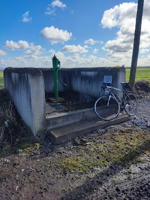
There's a small old school building here dating from 1840. Next to it is a brightly painted old Green Water Pump.

 Churchtown and its Medieval Font

The pump was manufactured by the Jessop Davis foundry at the Saint John's Ironworks in Enniscorthy, Wexford. Jessop Davis were makers of many of the old green Post Boxes still seen dotted about here and there.

Churchtown and its Medieval Font

I came across a small medieval Church ruin here one day while cycling about. The townland here is called Raheenadeeragh however the area is known as Churchtown.

Churchtown and its Medieval Font

It is situated in a quiet old graveyard and there is very little that remains of the building.

Churchtown and its Medieval Font

 It originally dates to the early 1200's according to records but it's also likely that an earlier Church preceded it on the site. The Church was dedicated to Saint Fintan who holds a special place in Laois history, culture and folklore.

Churchtown and its Medieval Font

There was a  Granite medieval font located here and it has now been placed with great care onto a specially made plinth. It is wonderful to see such care taken over these old antiquities.

Churchtown and its Medieval Font

Clearly visible are the marks/grooves which once held the hinges of a lid on the font.

Churchtown and its Medieval Font 

It would be nice to see Laois County Council allocated greater funding to take better care of the sites, monuments and antiquities under their auspices as has been done here. Far too many relics in Laois have been abandoned and lie buried under vegetation or are vanished or stolen.

Churchtown and its Medieval Font

There is a metal Cross in the graveyard which was erected by a Thomas Aldridge of New Zealand for his mother. It is the small things like this little detail which show the global interconnections that tie many different countries to this little Island on the western periphery of Europe.

Churchtown and its Medieval Font

While nothing of large scale is to be found here at Churchtown it's worth stopping by for a few moments if you happen to be passing nearby.


Keep the wheels turning.

Coordinates here :

53°00'33.3"N 7°03'09.0"W

53.009241, -7.052510

Churchtown and its Medieval Font


Churchtown and its Medieval Font


Saturday 21 May 2022

The Miners Way at Glendalough

 There's an area in the Glendalough valley with several different names.

It's a place called the old Lead Mines, Glendalough mines, the Miners Way and occasionally Van Diemen's Land.

Van Dieman's Land was a name once used to describe a place that is today called Tasmania. 

It is an Island off south east Australia and a part of that country.

The area of the Lead Mines here at Glendalough was nicknamed Van Diemen's Land because in the 1850's it seemed a remote, barren and desolate area. 

It too seemed very far removed from civilisation and much like Van Diemen's Land.

Van Diemen's Land in Australia was used as a Penal Colony by the British Government of the day and many Irish prisoners were shipped across the ocean to serve out their sentences thousands of miles from home.

This area was once a working mine where lead ore was mined by the Mining Company of Ireland and it was established in the 1850's.

Today it is somewhat less remote and being developed as a walking and recreation route which is to be encouraged.

There are a smattering of ruins which represent the buildings of the mining company and there are some small remnants of old disused and broken machinery to be found dotted about.

Large herds of deer roam the surrounding hillsides. The native Red Deer are quite wild while the smaller Sika are easier to get close to and seem to be less liable to startle.

Sika deer originated in Japan and were imported into Ireland. They were released in Wicklow circa 1860. Sika in Japanese means deer so correctly speaking they are properly referred to as Sika rather than Sika deer.

Fallow deer are also found in Wicklow. These are another introduced species and are believed to have been introduced into Ireland by Anglo Normans in the middle of the 13th century.

The Miners Way itself as of 2019 is now several colour coded waymarked walking trails. The trails are relatively easy to walk and well trodden. 

Decades ago they saw few visitors but today the routes both new and old see many visitors, especially throughout the summer months.

The Valleys at Glendalough are what are known as U shaped valleys. They were carved by enormous Ice age Glaciers and they do not have a sharp V shape associated with valleys carved by rivers and water.

Huge Glaciers scraped, gouged and moulded the valleys into the shape you see today as you look down on them from above. The mines at Glendalough are just one site representing a group of several mines nearby and in the surrounding areas.

This area is very scenic and worth visiting for a walk, perhaps while also including the nearby Monastic site on the valley floor.

The Miners Way - Wicklow Heritage


Coordinates here :

53°00'23.5"N 6°22'45.0"W

53.006540, -6.379156


Keep the wheels turning.