Baltinglass Hill Passage Tombs
At Baltinglass in Wicklow there are located rather unusually not one but three Neolithic Passage Tombs in one small space and several Bronze age Hillforts.
They are to be found to the rear of the village perched on top of the lovely green and verdant Baltinglass Hill.
The nature, position and layout of the numerous multi-period antiquities at Baltinglass make it somewhat misunderstood and perhaps difficult at first glance to appreciate its importance in the wider landscape. After all it's just a hill isn't it ?
Standing at around 380 metres elevation there's no doubt it's a hill however there is also little doubt that it isn't any ordinary hill.
Looking around through 360 degrees from the top of Baltinglass Hill it's possible to see the sites of many nearby Bronze Age Hillforts.
Also visible is the largest Bronze Age Hillfort in Ireland at the Brusselstown Ring/Spinan's Hill complex.
There are several earlier Neolithic sites in view including Lobawn and Keadeen Mountain which has what is believed from aerial photography to be a Cursus leading directly up the mountainside to the cairn of a Passage Tomb.
The spurs of Wicklow's tallest mountain, Luqnaquilla are also visible gently sloping nearby to the north east.
There may be many artefacts from antiquity absent from todays landscape however it nonetheless appears that Baltinglass Hill is located in a central position with regards to the surrounding monuments in this area of west Wicklow.
To the casual observer Baltinglass Hill easily suggests itself as the topographical centre of the immediate view.
While it's always possible to suggest that wherever the observer stands is to all intents and purposes the centre of the universe, the geography and topographic layout of the area surrounding Baltinglass Hill gives it wide, expansive and unobstructed views in all directions.
This hilltop vantage point may indeed have at one time been perceived as the centre of this little part of the universe.
Baltinglass Hill itself is home to Rathcoran Hillfort.
This large Bronze age monument is believed to be an unfinished and incomplete bivallate Hillfort. Bivallate simply means it had two outer enclosures.
The Hillfort itself is difficult to discern at ground level and is easier to see on the Google Maps aerial photographs pictured below.
The lower of the two photographs shows a second smaller trivallate Hillfort nearby (NNW) on Tuckmill Hill intersecting the wooded area.
The third aerial photograph which is from Bing Maps shows some nearby Hillforts including Tinoranhill multivallate Hillfort, Tuckmill, Baltinglass and Spinan's Hill and Brusselstown Ring.
Each of these sites circled in red is clearly visible from Baltinglass Hill.
The fourth and final aerial photograph shows a bird's eye view of what is believed to be a Cursus processional walkway and Passage Tomb cairn located to the east on nearby Keadeen Mountain.
Hopefully these few photographs help with understanding the layout and position of Baltinglass Hill.
Also located throughout the west Wicklow area are several Bronze age Stone circles, Standing stones and a least one Henge. Bronze age activity seems to have been particularly high in this small region of Wicklow.
There is some evidence at Baltinglass for a third Hillfort and multiple hut sites while several cairns are to be seen nearby which remain at present unclassified.
The verified archaeological remains and many scattered field monuments are the obvious and visible evidence of a site of major historical and archaeological importance.
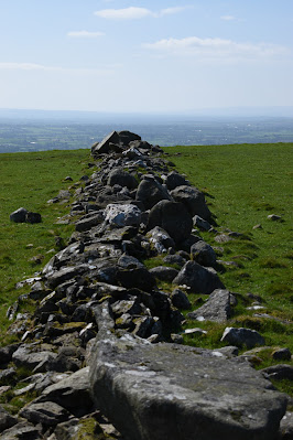
The Neolithic Passage Tombs and Bronze age burials on Baltinglass Hill are located within a small stone enclosure occasionally referred to incorrectly as a Cashel.
The Cashel is thought to be a type of stone built defensive enclosure generally dating to the late Iron age and early Christian era in Ireland. This particular structure is believed to be modern and contemporary.
It was constructed from stone material taken from the now denuded cairn which had previously covered the tombs and burial enclosures.
Unfortunately I can't provide an exact date for when this little enclosure was constructed on the Hill.
P.T. Walshe describes it in a 1940 paper as a "dry walled mearing fence".
Excavated in the mid 1930's there were five separate burial structures identified.
Three are classified as Passage Tombs and two are described as Cist like structures. The burials demonstrate a multi-period use of the site.
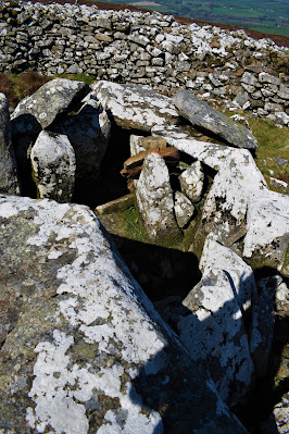
The Passage tombs today are in a poor condition and it is impossible to know how much damage was done both before and during the excavations of the 1930's.
There is rock art recorded on some of the kerb stones however it would probably prove difficult to locate today.
There are two rows of kerb stones, an inner and outer. Some of the kerb stones which would have lined the circumference of the burial Cairn are still "in situ" and make it easier to imagine the original form and function of the tombs.
One tomb in particular has several of its roof stones still in place and contained within this tomb is an intriguing Neolithic stone basin.
Perhaps this vessel held cremated remains or offerings at one stage many thousands of years ago.
It's unusual to see such a vessel still in place at a tomb and is a bit reminiscent of the large basin inside Newgrange Passage Tomb.
The Passage Tombs at Baltinglass are believed to date to circa 3600 B.C. It is also entirely possible they are perhaps several centuries earlier in construction.
Some of the items which have been uncovered at Baltinglass Hill include Pottery, Cremated bone, a Saddle Quern, an Egg shaped Stone, a Flint Javelin head, a Stone axe and Flint scrapers.
The monuments are located on private farmland which is used for grazing Sheep.
I would encourage potential visitors to arrange visiting with the landowner.
Jstor Access required for this link :
Coordinates here :
52°56'49.2"N 6°40'60.0"W
52.947001 - 6.683330


